161
161
Jan 26, 2013
01/13
by
KGO
tv
eye 161
favorite 0
quote 0
sift 7 in san jose. 58 at campbell. on the peninsula mid50s, 56 this san mateo and 57 in redwood city. we will see low to mid50s on the coast and pacifica 53 tomorrow. 55 at half moon bay. in and around san francisco mid50s tomorrow. 55 downtown and 54 in the sunset district. up in the north bay, pretty much narrow range of mid50s. 55 petaluma and 56 sonoma. slightly milder at napa with a high of 58. on the near east bay look for highs of 58 in oakland, castro valley. san leandro, 56. inland east bay it will be slow to warm up. highs just barely reaching the mid50s there. 56 at concord, danville and pleasanton and livermore. 54 at brentwood 57 in watsonville and santa cruz and farther inland 58 in gilroy and hollis store and -- hollister and 59 in salinas. forecast, the the seven-day forecast, the pattern holds steady for the first four days of the forecast period. temperatures in the mid50s through tuesday and little chance of rain. the best chance of a shower is this overnight period as the front passes through, and t
sift 7 in san jose. 58 at campbell. on the peninsula mid50s, 56 this san mateo and 57 in redwood city. we will see low to mid50s on the coast and pacifica 53 tomorrow. 55 at half moon bay. in and around san francisco mid50s tomorrow. 55 downtown and 54 in the sunset district. up in the north bay, pretty much narrow range of mid50s. 55 petaluma and 56 sonoma. slightly milder at napa with a high of 58. on the near east bay look for highs of 58 in oakland, castro valley. san leandro, 56. inland...
148
148
Jan 26, 2013
01/13
by
KGO
tv
eye 148
favorite 0
quote 0
sift 7 in san jose. 58 at campbell. on the peninsula mid50s, 56 this san mateo and 57 in redwood city. we will see low to mid50s on the coast and pacifica 53 tomorrow. 55 at half moon bay. in and around san francisco mid50s tomorrow. 55 downtown and 54 in the sunset district. up in the north bay, pretty much narrow range of mid50s. 55 petaluma and 56 sonoma. slightly milder at napa with a high of 58. on the near east bay look for highs of 58 in oakland, castro valley. san leandro, 56. inland east bay it will be slow to warm up. highs just barely reaching the mid50s there. 56 at concord, danville and pleasanton and livermore. 54 at brentwood 57 in watsonville and santa cruz and farther inland 58 in gilroy and hollis store and -- hollister and 59 in salinas. here is the seven-day forecast, the pattern holds steady for the first four days of the forecast period. temperatures in the mid50s through tuesday and little chance of rain. the best chance of a shower is this overnight period as the front passes through, and then dr
sift 7 in san jose. 58 at campbell. on the peninsula mid50s, 56 this san mateo and 57 in redwood city. we will see low to mid50s on the coast and pacifica 53 tomorrow. 55 at half moon bay. in and around san francisco mid50s tomorrow. 55 downtown and 54 in the sunset district. up in the north bay, pretty much narrow range of mid50s. 55 petaluma and 56 sonoma. slightly milder at napa with a high of 58. on the near east bay look for highs of 58 in oakland, castro valley. san leandro, 56. inland...
184
184
Jan 26, 2013
01/13
by
KOFY
tv
eye 184
favorite 0
quote 0
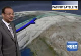
sift 7 in san jose. 58 at campbell. on the peninsula mid50s, 56 this san mateo and 57 in redwood city. we will see low to mid50s on the coast and pacifica 53 tomorrow. 55 at half moon bay. in and around san francisco mid50s tomorrow. 55 downtown and 54 in the sunset district. up in the north bay, pretty much narrow range of mid50s. 55 petaluma and 56 sonoma. slightly milder at napa with a high of 58. on the near east bay look for highs of 58 in oakland, castro valley. san leandro, 56. inland east bay it will be slow to warm up. highs just barely reaching the mid50s there. 56 at concord, danville and pleasanton and livermore. 54 at brentwood 57 in watsonville and santa cruz and farther inland 58 in gilroy and hollis store and -- hollister and 59 in salinas. here is the seven-day forecast, the pattern holds steady for the first four days of t forecast period. temperatures in the mid50s through tuesday and little chance of rain. the best chance of a shower is this overnight period as the front passes through, and then dry
sift 7 in san jose. 58 at campbell. on the peninsula mid50s, 56 this san mateo and 57 in redwood city. we will see low to mid50s on the coast and pacifica 53 tomorrow. 55 at half moon bay. in and around san francisco mid50s tomorrow. 55 downtown and 54 in the sunset district. up in the north bay, pretty much narrow range of mid50s. 55 petaluma and 56 sonoma. slightly milder at napa with a high of 58. on the near east bay look for highs of 58 in oakland, castro valley. san leandro, 56. inland...
87
87
Jan 26, 2013
01/13
by
KOFY
tv
eye 87
favorite 0
quote 0
high tomorrow 57 san jose. 58 campbell. 57 cupertino. on the planes we see high of 56 san mateo o. 57 palo alto and mountain view and on the coast 53 pacifica. 55 at half moon bay. up to san francisco downtown 56 the high tomorrow. 54 in the sun set district. 53 daly city. up north bay we see high mainly mid 50's. a little bit higher at santa rosa and calistoga which will top out at 57 and napa at 58. on the east bay lack for high of 26 in berkeley hayward san leandro union city. inland east bay relatively cool with high in the mid 50's. 55 at antioch. 56 livermore concord, 57 at fairfield and down near monterey bay look for high in the mid 50's near the bay. see upper 50's inland. 59 at is a lean as. 58 at gilroy and holster. accu-weather 7 day forecast. cooler pattern developing tomorrow. partly cloudy on sunday. tomorrow sunday monday and tuesday we see high pressure for mess part only in the mid 50's about 54 to 55 at most locations. we'll see temperatures moderating a little bit on wednesday then by thursday of next week high in the
high tomorrow 57 san jose. 58 campbell. 57 cupertino. on the planes we see high of 56 san mateo o. 57 palo alto and mountain view and on the coast 53 pacifica. 55 at half moon bay. up to san francisco downtown 56 the high tomorrow. 54 in the sun set district. 53 daly city. up north bay we see high mainly mid 50's. a little bit higher at santa rosa and calistoga which will top out at 57 and napa at 58. on the east bay lack for high of 26 in berkeley hayward san leandro union city. inland east...
212
212
Jan 26, 2013
01/13
by
KPIX
tv
eye 212
favorite 0
quote 0
one, that area of low pressure that gave you in san jose and milpitas and campbell and livermore all that heavy rainfall yesterday, well that heavy rainfall is now in southern california. but that same weather system is the catalyst for the sunshine and mild weather today. how does that happen? when it moves far enough away it takes the clouds with it but we still get the southerly influence. that's were we were mild today. factor in the sunshine and many of you were in the mid- to upper 60s. we look to the north for the next weathermaker where things typically come fro. a cold front will get here tomorrow. tiny chance of a shower north of the golden gate but we all will get cooler air. 60s tomorrow, no. we'll have highs in the mid- to upper 50s. by the top of next week, we are going to have cold nights lows in the 30s again down near freezing in the inland valleys and highs only in the mid-50s the cooler air moving in starting tomorrow. no more 60s for a while. slight chance of a weekend shower if i had to pinpoint one half of one day that would be the wettest, scattered showers on
one, that area of low pressure that gave you in san jose and milpitas and campbell and livermore all that heavy rainfall yesterday, well that heavy rainfall is now in southern california. but that same weather system is the catalyst for the sunshine and mild weather today. how does that happen? when it moves far enough away it takes the clouds with it but we still get the southerly influence. that's were we were mild today. factor in the sunshine and many of you were in the mid- to upper 60s....
 Live Music Archive
 Librivox Free Audio
 Metropolitan Museum
 Cleveland Museum of Art
 Internet Arcade
 Console Living Room
 Books to Borrow
 Open Library
 TV News
 Understanding 9/11